For those of you that surf, you know that feeling when you’re sitting in the lineup during a massive swell and you see a big black wall rising up on the horizon – the death set wave that you know is going to crash on your head? (For those of you who don’t surf – It’s not a good feeling. (see knot in stomach) knowing you’re about to be pummeled and held underwater for an undisclosed amount of time while you are “rag-dolled” being torn every direction as if in a washing machine)…
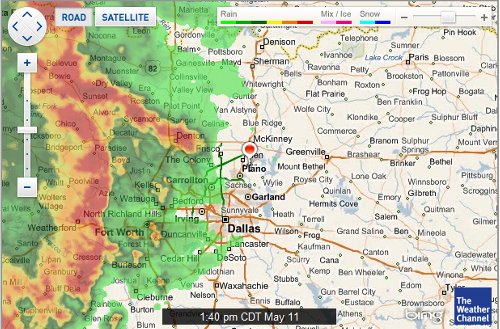
I just took a screen shot (post pic above) of the current weather map. The little bulbous marker thing near Plano – that’s us. That front of hellish disaster just West of us – that’s why the headlines on the Weather Channel say “Tornado Hunt Team Anticipates Busy Wednesday” today Yayyyy. For those of you who are not semi-professional meteorologists like myself let me give you a detailed analysis of the map above. RED IS BAD.
For our friends, family, fellow RV’ers, and blog lurkers who have been keeping tabs on us at all during our stint here in the northern Dallas Metroplex area of our journey (Allen, TX to be exact), you’ve probably heard us mention ohhhhh about a million times, the weather. I apologize. I realize for you hardened midwesterners who see this kinda thing every year it’s ({spits in spitoon} nuttin’ to worry ’bout) but for a guy who spent his entire life growing up in Southern California – it’s some crazy S#%^.
I started writing this at about 1:40pm today. Wednesday May 11, 2011. It’s now 2:21. I just checked back on weather.com and they’ve just issued the following at 2:15pm
* AT 215 PM CDT… NATIONAL WEATHER SERVICE METEOROLOGISTS DETECTED A LINE OF SEVERE THUNDERSTORMS CAPABLE OF PRODUCING QUARTER SIZE HAIL… AND DAMAGING WINDS IN EXCESS OF 65 MPH. THESE STORMS WERE LOCATED ALONG A LINE EXTENDING FROM 20 MILES WEST OF CELINA TO 8 MILES WEST OF COPPELL TO 15 MILES SOUTHWEST OF GRAND PRAIRIE… AND MOVING EAST AT 50 MPH.
This is actually good news compared to the “Severe Thunderstorm Warnings” we got all last week which included all that, flooding, and some tornado warnings to boot. Nothing in there so far about that. Yes, for your information I did just knock on the table next to me. We’re here visiting friends so I consider us very lucky to be able to weather some of these things in the house instead of the RV. We do however sleep in the RV every night and spending a couple nights out there with lightning strikes booming around us and 60+ mph winds rocking Dolly like a sailboat at anchor is pretty disconcerting interesting to say the least. We went ahead and decided to stay in the house last week though when the tornado sirens actually started blaring.
It is now 2:34 pm and as I write this last line the front edge of the storm just arrived – perfect timing lol. Ready on lighting – dim lighting. Cue driving rain. ACTION.
Tally ho…
Windblown,
Matt
P.S. We’ve taken a bunch of random short videos over the months and decided to post some of them on the blog under a new tab Videos in the navigation bar.
big ol fat rain
Yikes!! We got lucky and avoided all the bad weather – worst we experienced was a frozen hose in TN and a dust storm or two in New Mexico and Utah.
Tornados? SUCK. Drive for your lives!!
We have the jealousies. It’s great seeing friends here but I will be ready to be out of this crazy weather. Firing up Dolly and engaging the hyper drive. Whoosh.
Holy crap. Is the front speed / Dolly speed ratio greater than one?